

GARDEN ROUTE DISTRICT NEWS - As a severe cold front makes landfall in the Western Cape early tomorrow morning, Thursday 12 August, the South African Weather Service warns that heavy rain could result in floods in the Garden Route and Eastern Cape.
The front will spread to the Eastern Cape during the afternoon as well as parts of KwaZulu-Natal in the evening.
Rainy and very cold conditions with snow on the high-lying areas will set in over the Western Cape from tomorrow, progressing eastwards during the day.
A second system, a cut-off low, will develop during Friday 13 August over the western interior of the country, causing wintry conditions to persist over the southern parts of the country.
Moreover, the system is expected to deliver rainfall over the central interior of the country, a relatively uncommon occurrence for this time of year.
 Satellite image for Wednesday 11 August 2021, indicating the approaching cold front, located over the south-western Atlantic Ocean. Source: Eumetsat (2021).
Prepare for flooding
The first cold front will result in rainy and very cold condition in the Garden Route. Widespread rainfall of 15 to 35mm is expected over the southern parts of the Western Cape and the south-western parts of the Eastern Cape.
24-hour accumulated rainfall of up to 40 to 50mm is also likely along coastal and adjacent mountainous regions of the eastern Garden Route District, the south coast and adjacent interior of the Eastern Cape which may result in localised flooding of susceptible areas and roads.
Snowfall is expected over the eastern high-lying areas of the Western Cape, spreading to the high-lying areas of the Eastern Cape from the afternoon into the evening, persisting into Friday where some areas could experience traffic disruptions to some roads and mountain passes. Furthermore, snowfall is also expected to spread to the Drakensberg regions of KwaZulu-Natal from Thursday night onwards. The good news is that weather conditions will generally start to improve over the Western Cape during Friday, while cold conditions can be expected to arrive over parts of Mpumalanga and southern Gauteng.
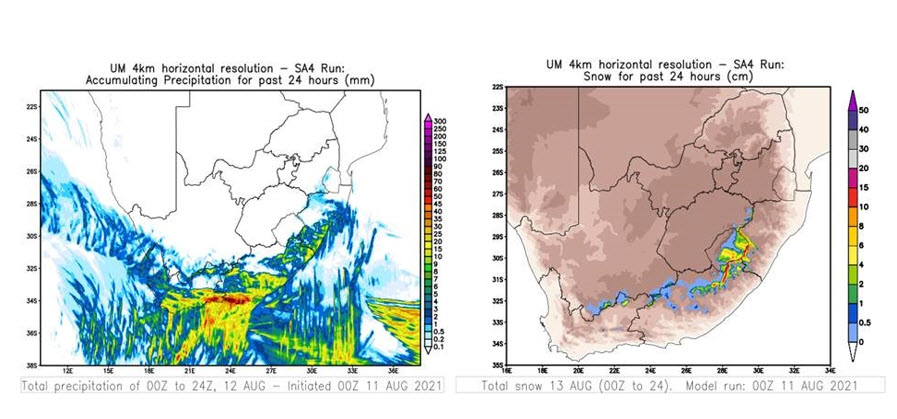 Twenty-four-hour rainfall accumulation in mm (at left) for Thursday (12 August 2021) and snowfall accumulation in cm (at right) for Friday (13 August 2021). Source: Unified Model (SAWS)
Second weather system
A cut-off low pressure system (an upper-air low pressure system displaced northwards and isolated from the original westerly wave regime), will develop during Friday over the western interior of the country. As a result, windy and cold conditions will prevail across most parts of the country during Friday and Saturday (13 to 14 August). Showers and thundershowers will develop in association with the cut-off low, affecting the eastern parts of the Northern Cape, Free State as well as the northern and eastern parts of the Eastern Cape.
Rainfall of 30 to 40mm can be expected over the extreme eastern parts of the Northern Cape, the south-western parts of the Free State and the extreme northern interior of the Eastern Cape, where very cold conditions will persist. Due to the dynamics of the upper-air system (characterised by very cold, unstable air aloft), some of the thunderstorms may become severe, resulting in large amounts of small hail. Snowfall is likely to continue over the northern high-lying areas of the Eastern Cape, Drakensberg mountains (encompassing the Eastern Cape and KwaZulu-Natal) and the extreme eastern parts of Free State, while light snowfall can be expected over the southern Free State and south-eastern Northern Cape. Last-mentioned snowfalls may result in further disruptions to traffic on major routes as well as the possible closure of mountain passes. In order to mitigate unexpected stock losses, it is strongly recommended that stock farmers move their smaller livestock to shelter at an early stage, ahead of the arrival of the winter weather.
 Predicted 24-hour rainfall accumulation in mm (at left) and maximum temperatures in degrees C (at right) for Saturday (14 August 2021). Source: GFS (NOAA)
The cut-off low pressure system is expected to exit the country during Sunday afternoon, allowing a spell of more settled, warmer weather to return during the following week.
Visit www.weathersa.co.za as well as via the SA Weather Service Twitter account @SAWeatherServic for regular updates.
'We bring you the latest Garden Route, Karoo, Hessequa news'


